
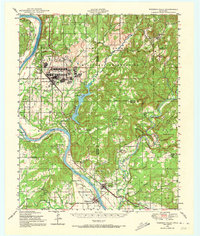
1948 Map of Webbers Falls
USGS Topo · Published 1966About this map
Camp Gruber Military Reservation dominates the landscape of this 1940s survey, showing the extensive infrastructure of the World War II-era training facility, including its Rifle Ranges, Landing Field, and barracks. This military presence is situated alongside long-established settlements and family homesteads near the confluence of the Arkansas River and the Illinois River. The topography is defined by significant bluffs like Beetle Bluff and Padgett Bluff, which overlook the winding river bends.
Find a feature on this map
84 named features on this map. Tap any name to fly to it.
Don’t see what you’re looking for? This feature index may not catch every label — zoom into the map to look around manually.
Map Details
Editions of this 1948 Webbers Falls Map
2 editions found
Other maps of this area

1898 · Tahlequah
USGS Topo · 1:125,000

1900 · Sansbois
USGS Topo · 1:125,000

1900 · Sallisaw
USGS Topo · 1:125,000

1901 · Muscogee
USGS Topo · 1:125,000

1901 · Tahlequah
USGS Topo · 1:125,000

1905 · Muscogee
USGS Topo · 1:125,000

1905 · Tahlequah
USGS Topo · 1:125,000

1909 · Sans Bois
USGS Topo · 1:125,000

1911 · Sallisaw
USGS Topo · 1:125,000

1911 · Sansbois
USGS Topo · 1:125,000