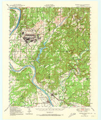
1948 Map of Webbers Falls
USGS Topo · Published 1973About this map
The Camp Gruber military reservation dominates the northern landscape of this post-war Oklahoma survey, featuring a dense network of barracks, rifle ranges, and a landing field. This massive training facility contrasts sharply with the established river towns of Webbers Falls and Gore to the south. The serpentine Arkansas River and the Illinois River carve through the terrain, creating prominent landmarks like Beetle Bluff and Padgett Bluff. Evidence of rural community life is scattered throughout the hills, marked by schools such as Pigeon Sch and Red Bird Smith Indian Monument Sch, alongside the Missouri Pacific railroad corridor. The presence of Greenleaf Lake and the numerous named ridges like Merford Ridge suggest a landscape transitioning from traditional agriculture toward federal land use and early water management projects.
Find a feature on this map
76 named features on this map. Tap any name to fly to it.
Don’t see what you’re looking for? This feature index may not catch every label — zoom into the map to look around manually.
Map Details
Editions of this 1948 Webbers Falls Map
2 editions found

Other maps of this area

1898 · Tahlequah
USGS Topo · 1:125,000

1900 · Sansbois
USGS Topo · 1:125,000

1900 · Sallisaw
USGS Topo · 1:125,000

1901 · Muscogee
USGS Topo · 1:125,000

1901 · Tahlequah
USGS Topo · 1:125,000

1905 · Muscogee
USGS Topo · 1:125,000

1905 · Tahlequah
USGS Topo · 1:125,000

1909 · Sans Bois
USGS Topo · 1:125,000

1911 · Sallisaw
USGS Topo · 1:125,000

1911 · Sansbois
USGS Topo · 1:125,000