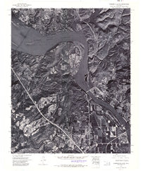
1972 Map of Webbers Falls SW
USGS Topo · Published 1974About this map
Arkansas River hydrology and mid-century infrastructure dominate this orthophotomosaic, captured via aerial photography in the early 1970s. The landscape is defined by the massive Webbers Falls Reservoir, created following the completion of the Webbers Falls Dam. This engineering feat significantly altered the local geography of Muskogee County, submerging much of the low-lying river valley to manage navigation and power. The town of Webbers Falls is visible in the southeast, situated near the riverbanks below the reservoir's reach. To the north, the waters of Greenleaf Lake feed into the system, surrounded by the wooded, uneven terrain typical of this portion of eastern Oklahoma. The map's photographic detail provides a unique look at land use patterns and agricultural clearings as they existed just years after the reservoir reached its full pool.
Find a feature on this map
5 named features on this map. Tap any name to fly to it.
Don’t see what you’re looking for? This feature index may not catch every label — zoom into the map to look around manually.
Map Details
Editions of this 1972 Webbers Falls SW Map
This is the sole edition of this map. No revisions or reprints were ever made.
Other maps of this area

1900 · Sansbois
USGS Topo · 1:125,000

1901 · Muscogee
USGS Topo · 1:125,000

1905 · Muscogee
USGS Topo · 1:125,000

1909 · Sans Bois
USGS Topo · 1:125,000

1911 · Sansbois
USGS Topo · 1:125,000

1946 · Fort Smith
USGS Topo · 1:250,000

1948 · Keefeton
USGS Topo · 1:62,500

1948 · Webbers Falls
USGS Topo · 1:62,500

1950 · Keefeton
USGS Topo · 1:62,500

1950 · Webbers Falls
USGS Topo · 1:62,500