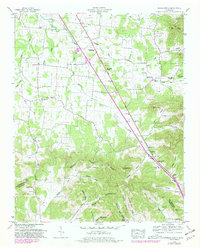
1949 Map of Webbs Jungle
USGS Topo · Published 1981About this map
The Middle Fork Stones River carves a path through this central Tennessee landscape, following a valley corridor flanked by the distinctive knobs and hollows of Rutherford and Bedford Counties. The Dixie Highway West serves as the primary artery for the region, passing through notable local landmarks like Hoovers Gap and near the namesake community of Webbs Jungle. This era of documentation reveals a rural social structure anchored by numerous country churches, such as Mt Carmel Church and New Hope Church, alongside small local educational centers like the Buchanan School. The geography is defined by the Tennessee Valley Divide, with the terrain transitioning from the lower valley floors to higher elevations like Pilot Knob and Locust Knob. Settlement patterns are evident in small hamlets like Big Springs and Gum, where family-named cemeteries such as Todd Cem and Robinson Cem provide significant genealogical value.
Find a feature on this map
73 named features on this map. Tap any name to fly to it.
Don’t see what you’re looking for? This feature index may not catch every label — zoom into the map to look around manually.
Map Details
Editions of this 1949 Webbs Jungle Map
3 editions found
Other maps of this area

1908 · Woodbury
USGS Topo · 1:62,500

1913 · Hollow Springs
USGS Topo · 1:62,500

1916 · Murfreesboro
USGS Topo · 1:62,500

1936 · Webbs Jungle
USGS Topo · 1:24,000

1936 · Deason
USGS Topo · 1:24,000

1936 · Beech Grove
USGS Topo · 1:24,000

1936 · Noah
USGS Topo · 1:24,000

1936 · Wartrace
USGS Topo · 1:24,000

1936 · Fosterville
USGS Topo · 1:24,000

1942 · Statesville
USGS Topo · 1:100,000