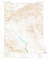
1951 Map of Weber Reservoir
USGS Topo · Published 1966About this map
Weber Reservoir dominates this high-desert landscape in west-central Nevada, serving as a primary water source for the surrounding Walker River Indian Reservation. The Walker River snakes through Campbell Valley before being impounded, with the Lateral Canal and Spillway indicating early water management infrastructure. This 1951 survey documents a region defined by isolation and elevation, with the Singatse Range and Dead Camel Mts framing the basins.
Find a feature on this map
26 named features on this map. Tap any name to fly to it.
Don’t see what you’re looking for? This feature index may not catch every label — zoom into the map to look around manually.
Map Details
Editions of this 1951 Weber Reservoir Map
5 editions found

Other maps of this area

1891 · Wabuska
USGS Topo · 1:125,000

1891 · Wellington
USGS Topo · 1:125,000

1893 · Wellington
USGS Topo · 1:125,000

1894 · Wabuska
USGS Topo · 1:125,000

1908 · Carson Sink
USGS Topo · 1:250,000

1909 · Hawthorne
USGS Topo · 1:250,000

1910 · Carson Sink
USGS Topo · 1:250,000

1911 · Hawthorne
USGS Topo · 1:250,000

1915 · Hawthorne
USGS Topo · 1:250,000

1948 · Walker Lake
USGS Topo · 1:250,000