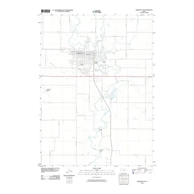
2010 Map of Webster City
USGS Topo · Published 2010About this map
The Boone River snakes through the heart of Webster City, serving as a central geographic anchor for this Hamilton County community. The city's layout is defined by its intersection of river and rail heritage, though by this era, the landscape is increasingly shaped by local cultural landmarks like the Bonebright Museum Complex and the Hamilton County Speedway. The northern reaches of the city are bounded by the confluence of the river with White Fox Creek and Lyons Creek, while the western edge is marked by the Webster City Municipal Airport.
Find a feature on this map
44 named features on this map. Tap any name to fly to it.
Don’t see what you’re looking for? This feature index may not catch every label — zoom into the map to look around manually.
Map Details
Editions of this 2010 Webster City Map
This is the sole edition of this map. No revisions or reprints were ever made.
Other maps of this area

1954 · Waterloo
USGS Topo · 1:250,000

1955 · Waterloo
USGS Topo · 1:250,000

1978 · Blairsburg
USGS Topo · 1:24,000

1978 · Woolstock
USGS Topo · 1:24,000

1978 · Eagle Grove SW
USGS Topo · 1:24,000

1978 · Webster City
USGS Topo · 1:24,000
1978 · Stanhope
USGS Topo · 1:24,000

1978 · Jewell
USGS Topo · 1:24,000

1978 · Clarion SW
USGS Topo · 1:24,000
1978 · Duncombe
USGS Topo · 1:24,000