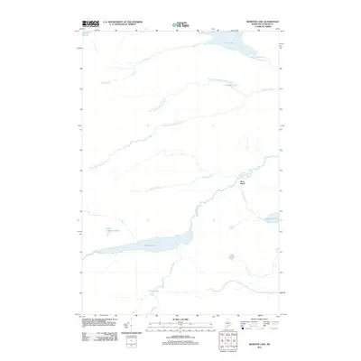
2011 Map of Webster Lake
USGS Topo · Published 2011About this map
Webster Lake serves as the central focal point of this North Maine Woods landscape, providing the primary basin for drainage networks that define the local geography. In this 2011 survey, the waterway transitions into Webster Brook, which meanders eastward past Pine Knoll toward the East Branch Penobscot River. The surrounding terrain is characterized by a series of interconnected ponds and brooks, including the remote Little Coffeelos Pond and the expansive Thissell Bog to the south. This environment reflects a deep wilderness character, where naming conventions like Lost Pond and Snake Pond speak to the isolation of the Piscataquis County backcountry. The intricate branching of North Branch Brayley Brook and South Branch Brayley Brook illustrates the complex hydrological system that supports the region's timberlands and protected natural areas.
Find a feature on this map
20 named features on this map. Tap any name to fly to it.
Don’t see what you’re looking for? This feature index may not catch every label — zoom into the map to look around manually.
Map Details
Editions of this 2011 Webster Lake Map
This is the sole edition of this map. No revisions or reprints were ever made.
Other maps of this area

1953 · Telos Lake
USGS Topo · 1:62,500

1954 · Spider Lake
USGS Topo · 1:62,500

1954 · Millinocket Lake
USGS Topo · 1:62,500

1954 · Presque Isle
USGS Topo · 1:250,000

1955 · Traveler Mountain
USGS Topo · 1:62,500

1957 · Telos Lake
USGS Topo · 1:62,500

1958 · Presque Isle
USGS Topo · 1:250,000

1960 · Presque Isle
USGS Topo · 1:250,000

1961 · Spider Lake
USGS Topo · 1:62,500
1975 · Traveler Mountain NW
USGS Topo · 1:24,000