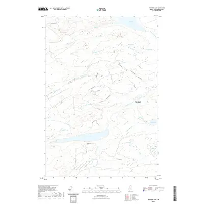
2021 Map of Webster Lake
USGS Topo · Published 2021About this map
Webster Lake dominates the southern half of this landscape, fed by the winding Webster Brook and surrounded by a complex network of forest access roads including Webster Lake Rd and Freeze Out Rd. This territory in Piscataquis County is defined by its diverse wetlands and water bodies, from the expanse of Third Lake at the northern edge to the remote Little Coffeelos Pond and Hudson Pond. The hydrology of the area is particularly intricate, with the E Br Penobscot River flowing through the northeast corner while the various branches of Brayley Brook drain the central uplands near Pine Knoll. Evidence of the region's managed wilderness and logging history is visible in the names of thoroughfares like Snake Pond Rd, Catamount Rd, and Murphy Brook Rd, which provide access to secluded spots like Thissell Bog and Wadleigh Bog.
Find a feature on this map
35 named features on this map. Tap any name to fly to it.
Don’t see what you’re looking for? This feature index may not catch every label — zoom into the map to look around manually.
Map Details
Editions of this 2021 Webster Lake Map
This is the sole edition of this map. No revisions or reprints were ever made.
Other maps of this area

1953 · Telos Lake
USGS Topo · 1:62,500

1954 · Spider Lake
USGS Topo · 1:62,500

1954 · Millinocket Lake
USGS Topo · 1:62,500

1954 · Presque Isle
USGS Topo · 1:250,000

1955 · Traveler Mountain
USGS Topo · 1:62,500

1957 · Telos Lake
USGS Topo · 1:62,500

1958 · Presque Isle
USGS Topo · 1:250,000

1960 · Presque Isle
USGS Topo · 1:250,000

1961 · Spider Lake
USGS Topo · 1:62,500
1975 · Traveler Mountain NW
USGS Topo · 1:24,000