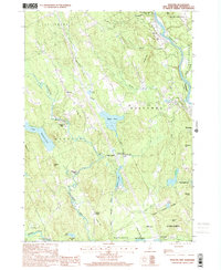
2000 Map of Webster
USGS Topo · Published 2001About this map
The Blackwater River and Merrimack River define this corner of New Hampshire, where the town of Webster meets the corporate boundaries of Concord. This survey, based on imagery from the late 20th century, illustrates a landscape heavily managed for water control and conservation, anchored by the Blackwater Dam and several state-managed wildlands including the Kimball State Wildlife Management Area.
Find a feature on this map
52 named features on this map. Tap any name to fly to it.
Don’t see what you’re looking for? This feature index may not catch every label — zoom into the map to look around manually.
Map Details
Editions of this 2000 Webster Map
This is the sole edition of this map. No revisions or reprints were ever made.
Other maps of this area

1926 · Hillsboro
USGS Topo · 1:62,500

1927 · Concord
USGS Topo · 1:62,500

1927 · Penacook
USGS Topo · 1:62,500

1928 · Mount Kearsarge
USGS Topo · 1:62,500

1929 · Hillsboro
USGS Topo · 1:62,500

1931 · Mount Kearsarge
USGS Topo · 1:62,500

1949 · Portland
USGS Topo · 1:250,000

1949 · Concord
USGS Topo · 1:62,500

1956 · Penacook
USGS Topo · 1:62,500

1956 · Mt. Kearsarge
USGS Topo · 1:62,500