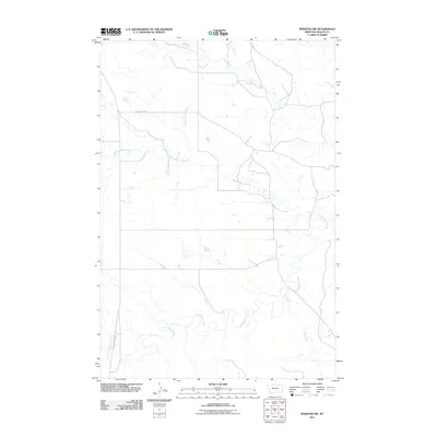
2011 Map of Webster NW
USGS Topo · Published 2011About this map
Little Beaver Creek and its seasonal tributaries define the drainage patterns of this Fallon County landscape, where the high plains terrain is marked by the winding courses of Hidden Water Creek and Mud Creek. This 2011 survey illustrates a sparsely populated region of Montana where the human footprint is primarily seen through a grid of secondary roads and local routes. The infrastructure is anchored by County Hwy 322 and Country Road 4, which provide the primary access through the open country. The mapping detail shows the subtle topography of the prairie, characterized by broad drainage basins and the intermittent watercourses essential to life and ranching in the eastern reaches of the state.
Find a feature on this map
5 named features on this map. Tap any name to fly to it.
Don’t see what you’re looking for? This feature index may not catch every label — zoom into the map to look around manually.
Map Details
Editions of this 2011 Webster NW Map
This is the sole edition of this map. No revisions or reprints were ever made.
Other maps of this area

1953 · Miles City
USGS Topo · 1:250,000

1957 · Miles City
USGS Topo · 1:250,000

1958 · Miles City
USGS Topo · 1:250,000

1981 · Webster NW
USGS Topo · 1:24,000

1981 · Baker
USGS Topo · 1:100,000

1981 · Buffalo Reservoir
USGS Topo · 1:24,000
1981 · Scole School
USGS Topo · 1:24,000

1981 · Baker
USGS Topo · 1:24,000

1981 · Willard
USGS Topo · 1:24,000
1981 · Willard SE
USGS Topo · 1:24,000