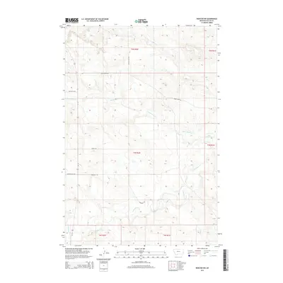
2014 Map of Webster NW
USGS Topo · Published 2014About this map
Little Beaver Cr and Hidden Water Cr carve through the high plains of Fallon County, defining the drainage patterns of this sparsely populated ranching landscape. This 2014 survey captures a terrain organized by the Public Land Survey System, where modern access roads like Brackett Butte Rd and Bergstrom Hill Rd follow the rigid grid of section lines. The map reveals a network of primitive routes and trails, such as the Hidden Water Trl and Wrangler Trl, which navigate the elevation changes between the creek beds and the higher buttes. To the southeast, Mud Cr enters the frame, marking another low-lying watercourse in a region where geography is largely dictated by these seasonal and intermittent streams and the name-bearing buttes that rise above the plateau.
Find a feature on this map
15 named features on this map. Tap any name to fly to it.
Don’t see what you’re looking for? This feature index may not catch every label — zoom into the map to look around manually.
Map Details
Editions of this 2014 Webster NW Map
This is the sole edition of this map. No revisions or reprints were ever made.
Other maps of this area

1953 · Miles City
USGS Topo · 1:250,000

1957 · Miles City
USGS Topo · 1:250,000

1958 · Miles City
USGS Topo · 1:250,000

1981 · Webster NW
USGS Topo · 1:24,000

1981 · Baker
USGS Topo · 1:100,000

1981 · Buffalo Reservoir
USGS Topo · 1:24,000
1981 · Scole School
USGS Topo · 1:24,000

1981 · Baker
USGS Topo · 1:24,000

1981 · Willard
USGS Topo · 1:24,000
1981 · Willard SE
USGS Topo · 1:24,000