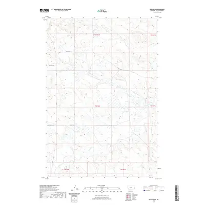
2020 Map of Webster NW
USGS Topo · Published 2020About this map
Little Beaver Cr and Hidden Water Cr carve through this section of Fallon County, Montana, defining a landscape marked by seasonal drainage and ranching access. The terrain is crisscrossed by several primitive routes and cattle trails, such as the Wrangler Trl and Hidden Water Trl, which follow the natural contours of the drainages. These routes, including Wiley Butte Trl and Bergstrom Hill Rd, indicate a sparse but functional network for land management and movement across the broken prairie. The inclusion of Mud Cr in the southeastern corner further illustrates the hydrologic pattern typical of the region, where water sources are vital yet ephemeral features of the high plains. This survey provides a look at the remote corners of eastern Montana, showing how local landmarks like the buttes and creek beds dictate the placement of rural roads like Brackett Butte Rd.
Find a feature on this map
14 named features on this map. Tap any name to fly to it.
Don’t see what you’re looking for? This feature index may not catch every label — zoom into the map to look around manually.
Map Details
Editions of this 2020 Webster NW Map
This is the sole edition of this map. No revisions or reprints were ever made.
Other maps of this area

1953 · Miles City
USGS Topo · 1:250,000

1957 · Miles City
USGS Topo · 1:250,000

1958 · Miles City
USGS Topo · 1:250,000

1981 · Webster NW
USGS Topo · 1:24,000

1981 · Baker
USGS Topo · 1:100,000

1981 · Buffalo Reservoir
USGS Topo · 1:24,000
1981 · Scole School
USGS Topo · 1:24,000

1981 · Baker
USGS Topo · 1:24,000

1981 · Willard
USGS Topo · 1:24,000
1981 · Willard SE
USGS Topo · 1:24,000