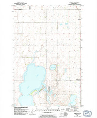
1994 Map of Webster
USGS Topo · Published 1994About this map
Dry Lake and the surrounding prairie wetlands dominate this portion of the northern plains, reflecting a landscape defined by seasonal water levels and conservation efforts. The 1994 revision highlights the significant National Waterfowl Production Area straddling the transition between Dry Lake and the Freshwater marshes near Cavanaugh Lake. This area serves as a critical junction for local history and ecology, where the small community of Webster and the nearby Garske provide anchor points for the surrounding rural townships. Genealogists may find value in the location of the Webster Cem, situated just west of the main settlement and north of the marshes. The map provides a detailed view of the township system across Hammer, Webster, and Degroat, illustrating the grid-like settlement patterns characteristic of Ramsey County.
Find a feature on this map
13 named features on this map. Tap any name to fly to it.
Don’t see what you’re looking for? This feature index may not catch every label — zoom into the map to look around manually.
Map Details
Editions of this 1994 Webster Map
This is the sole edition of this map. No revisions or reprints were ever made.
Other maps of this area

1931 · Devils Lake
USGS Topo · 1:62,500

1932 · Grahams Island
USGS Topo · 1:62,500

1950 · Grahams Island
USGS Topo · 1:62,500

1950 · Devils Lake
USGS Topo · 1:62,500

1951 · Grand Harbor
USGS Topo · 1:24,000

1951 · Penn
USGS Topo · 1:24,000

1951 · Sweetwater
USGS Topo · 1:24,000

1953 · Devils Lake
USGS Topo · 1:250,000

1956 · Devils Lake
USGS Topo · 1:250,000

1957 · Cando SE
USGS Topo · 1:24,000