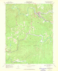
1966 Map of Webster Springs
USGS Topo · Published 1970About this map
The Elk River and its confluence with the Back Fork Elk River anchor this mid-century look at the Webster County seat. The village of Webster Springs serves as the primary hub, surrounded by mountain settlements like Bolair, Cherry Falls, and Parcoal. A landscape defined by industrial activity and public land, the map reveals numerous strip mines and a large Quarry dotting the ridges above the Gauley River. The southern half of the sheet is largely occupied by the Monongahela National Forest, where the Williams River snakes through the hollows. Evidence of community life is found at Camp Caesar and rural houses of worship such as Pleasant Ridge Ch and Beaver Run Ch. Transportation is dictated by the water, with the Baltimore and Ohio railroad following the riverbanks to service the region's timber and coal operations.
Find a feature on this map
61 named features on this map. Tap any name to fly to it.
Don’t see what you’re looking for? This feature index may not catch every label — zoom into the map to look around manually.
Map Details
Editions of this 1966 Webster Springs Map
2 editions found
Other maps of this area

1889 · Nicholas
USGS Topo · 1:125,000

1891 · Nicholas
USGS Topo · 1:125,000

1891 · Huntersville
USGS Topo · 1:125,000

1893 · Buckhannon
USGS Topo · 1:125,000

1893 · Sutton
USGS Topo · 1:125,000

1894 · Huntersville
USGS Topo · 1:125,000

1896 · Buckhannon
USGS Topo · 1:125,000

1897 · Buckhannon
USGS Topo · 1:125,000

1901 · Nicholas
USGS Topo · 1:125,000

1908 · Sutton
USGS Topo · 1:48,000
Featured Places
- Addison (Webster Springs), WV
- Webster Springs, Addison (Webster Springs)
- Skidmore Crossing, WV
- Bolair, WV
- Excelsior, WV