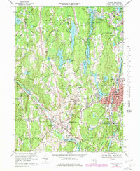
1969 Map of Webster
USGS Topo · Published 1979About this map
The industrial and academic hub of Webster and Dudley anchors this 1969 survey, showing the intricate relationship between the region's river systems and its mid-century development. The French River powers its way through the eastern portion of the map, passing North Village and Perryville before crossing into Connecticut. Further west, the Quinebaug River winds past West Dudley, while the Providence and Worcester railroad corridor maintains the vital transport link through the valley.
Find a feature on this map
95 named features on this map. Tap any name to fly to it.
Don’t see what you’re looking for? This feature index may not catch every label — zoom into the map to look around manually.
Map Details
Editions of this 1969 Webster Map
4 editions found
Other maps of this area

1887 · Brookfield
USGS Topo · 1:62,500

1889 · Webster
USGS Topo · 1:62,500

1889 · Putnam
USGS Topo · 1:62,500

1890 · Brookfield
USGS Topo · 1:62,500

1892 · Woodstock
USGS Topo · 1:62,500

1892 · Webster
USGS Topo · 1:62,500

1893 · Putnam
USGS Topo · 1:62,500

1893 · Brookfield
USGS Topo · 1:62,500

1908 · Quinsigamond
USGS Topo · 1:125,000

1908 · Ware
USGS Topo · 1:125,000