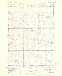
1952 Map of Wecota
USGS Topo · Published 1952About this map
Wecota sits at the heart of this prairie landscape, serving as a focal point for the surrounding rural townships of Liberty, Freedom, and Emerson. The map illustrates a transitional period for regional transportation, specifically marking an Old Railroad Grade that once connected these agricultural communities to broader markets. Local life and genealogy are well-preserved through the inclusion of several one-room schoolhouses such as North Freedom Sch, Lindhorst Sch, and Kellett Sch, alongside the Immanuel Ch and its adjacent Immanuel Cem. To the east, the waters of Lake Cresbard are visible, complete with a recorded Spillway elevation. The survey provides a clear view of the section-line road network and the numerous small depressions and sloughs characteristic of the glacial till plains in this part of South Dakota.
Find a feature on this map
17 named features on this map. Tap any name to fly to it.
Don’t see what you’re looking for? This feature index may not catch every label — zoom into the map to look around manually.
Map Details
Editions of this 1952 Wecota Map
2 editions found
Other maps of this area

1899 · Northville
USGS Topo · 1:125,000

1952 · Norbeck
USGS Topo · 1:24,000

1952 · Wecota
USGS Topo · 1:24,000

1952 · Faulkton West
USGS Topo · 1:24,000

1952 · Faulkton East
USGS Topo · 1:24,000

1954 · Aberdeen
USGS Topo · 1:250,000

1956 · Aberdeen
USGS Topo · 1:250,000
1966 · Cresbard SW
USGS Topo · 1:24,000

1966 · Cresbard
USGS Topo · 1:24,000

1970 · Mina SW
USGS Topo · 1:24,000