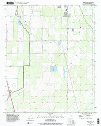
1992 Map of Weed Patch
USGS Topo · Published 1995About this map
Agricultural development and water management define this portion of the San Joaquin Valley, where the settlements of Lamont and Weed Patch sit amidst a grid of irrigation infrastructure. The landscape is characterized by its history as a hydraulic basin, specifically the Kern Lake Bed, which is now dominated by agricultural tracts and a complex network of canals and drains. The Kern Island Canal and Buena Vista Canal move water across the terrain, supported by the Kern Island Drain and numerous levees. Beyond the farming operations, the map identifies specific industrial and aviation markers, including a Test Site, an Airway Beacon, and multiple landing strips. The road network, featuring Weed Patch Highway and Bear Mountain Boulevard, follows the rigid section lines of the township and range system, reflecting the highly organized nature of this rural industrial corridor south of Bakersfield.
Find a feature on this map
31 named features on this map. Tap any name to fly to it.
Don’t see what you’re looking for? This feature index may not catch every label — zoom into the map to look around manually.
Map Details
Editions of this 1992 Weed Patch Map
2 editions found
Other maps of this area

1910 · Buena Vista Lake
USGS Topo · 1:125,000

1912 · Buena Vista Lake
USGS Topo · 1:125,000

1914 · Caliente
USGS Topo · 1:125,000

1929 · Fairfax School
USGS Topo · 1:31,680

1930 · Weed Patch
USGS Topo · 1:31,680

1930 · Arvin
USGS Topo · 1:31,680

1930 · Conner
USGS Topo · 1:31,680

1931 · West of Tejon Hills
USGS Topo · 1:31,680

1931 · Edison
USGS Topo · 1:31,680

1931 · Tejon Hills
USGS Topo · 1:31,680