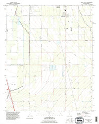
1992 Map of Weed Patch
USGS Topo · Published 1995About this map
Agricultural development and water management systems dominate this part of the San Joaquin Valley, where the settlements of Weed Patch and Lamont sit within a grid of orchards and fields. The map documents an intricate network of irrigation infrastructure essential to the region's productivity, including the Kern Island Drain, the Central Branch Kern Island Canal, and the East Side Canal. These man-made waterways contrast with the natural depression of the Kern Lake Bed in the southwest, a remnant of the historic hydrology before large-scale diversion.
Find a feature on this map
18 named features on this map. Tap any name to fly to it.
Don’t see what you’re looking for? This feature index may not catch every label — zoom into the map to look around manually.
Map Details
Editions of this 1992 Weed Patch Map
2 editions found
Other maps of this area

1910 · Buena Vista Lake
USGS Topo · 1:125,000

1912 · Buena Vista Lake
USGS Topo · 1:125,000

1914 · Caliente
USGS Topo · 1:125,000

1929 · Fairfax School
USGS Topo · 1:31,680

1930 · Weed Patch
USGS Topo · 1:31,680

1930 · Arvin
USGS Topo · 1:31,680

1930 · Conner
USGS Topo · 1:31,680

1931 · West of Tejon Hills
USGS Topo · 1:31,680

1931 · Edison
USGS Topo · 1:31,680

1931 · Tejon Hills
USGS Topo · 1:31,680