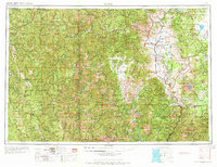
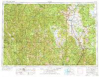
1958 Map of Weed
USGS Topo · Published 1973About this map
The Siskiyou Mountains and Marble Mountains dominate this 1950s survey, revealing a landscape defined by massive tectonic uplift and the drainage basins of the Smith River. This compilation by the Army Map Service and U.S. Geological Survey provides a high-altitude perspective on the complex topography of the Pacific Northwest, where the Scott Mountains meet the western edge of the Cascade Range. The map reflects a mid-century period of land management and resource mapping, documenting the extensive network of ridgelines and water systems before modern development altered these remote northern California and southern Oregon corridors. The spatial relationship between these major ranges highlights the region's geological diversity, from the volcanic influence of the Cascades to the ancient metamorphic blocks of the Siskiyous.
Find a feature on this map
5 named features on this map. Tap any name to fly to it.
Don’t see what you’re looking for? This feature index may not catch every label — zoom into the map to look around manually.
Map Details
Editions of this 1958 Weed Map
3 editions found

Other maps of this area

1886 · Lassen Peak
USGS Topo · 1:250,000

1886 · Modoc Lava Bed
USGS Topo · 1:250,000

1886 · Shasta
USGS Topo · 1:250,000

1889 · Klamath
USGS Topo · 1:250,000

1890 · Red Bluff
USGS Topo · 1:250,000

1891 · Ashland
USGS Topo · 1:250,000

1892 · Modoc Lava-Bed
USGS Topo · 1:250,000

1892 · Lassen Peak
USGS Topo · 1:250,000

1893 · Ashland
USGS Topo · 1:250,000

1894 · Lassen Peak
USGS Topo · 1:250,000