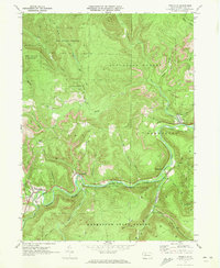
1970 Map of Weedville
USGS Topo · Published 1973About this map
Bennett Branch Sinnemahoning Creek carves a deep valley through the center of this 1970 survey, anchoring a landscape where narrow floodplains host the primary transportation and settlement corridors. The Penn Central railroad follows the winding river course, connecting the communities of Weedville, Caledonia, and Benezette. This era is defined by the heavy presence of energy and conservation, seen in the numerous Gas Wells dotting the southern hills and the active Strip Mines on the ridges.
Find a feature on this map
30 named features on this map. Tap any name to fly to it.
Don’t see what you’re looking for? This feature index may not catch every label — zoom into the map to look around manually.
Map Details
Editions of this 1970 Weedville Map
3 editions found
Other maps of this area

1929 · Clearfield
USGS Topo · 1:48,000

1929 · Penfield
USGS Topo · 1:62,500

1932 · Clearfield
USGS Topo · 1:62,500

1932 · Penfield
USGS Topo · 1:62,500

1941 · Benezette
USGS Topo · 1:62,500

1941 · Ridgway
USGS Topo · 1:62,500

1943 · Benezette
USGS Topo · 1:62,500

1944 · Ridgway
USGS Topo · 1:62,500

1957 · Warren
USGS Topo · 1:250,000

1958 · Warren
USGS Topo · 1:250,000
Featured Places
- Benezette Township, PA
- Jay Township, PA
- Medix Run, Benezette Township
- Caledonia, Jay Township
- Weedville, Jay Township