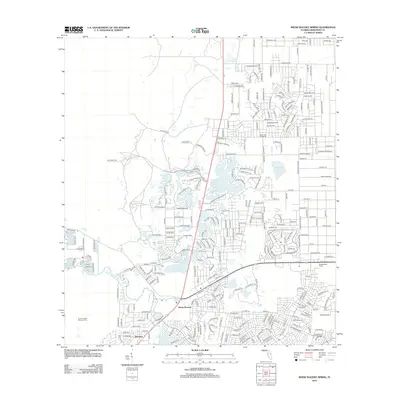
2012 Map of Weeki Wachee Spring
USGS Topo · Published 2012About this map
Weeki Wachee Spring serves as the hydrological centerpiece of this West Florida landscape, feeding the Weeki Wachee River as it flows toward the Gulf. The 2012 survey illustrates a transition from the dense residential grids of Weeki Wachee and Berkeley in the south to the more open, wetland-dotted terrain of northern Hernando County. This northern reach is characterized by numerous water bodies including Coon Wallow, Tooke Lake, and Whitehurst Pond, which are interwoven with an expanding network of suburban thoroughfares like Centralia Rd and Bourassa Blvd. Local landmarks such as the Weekiwachee Tower and Great Hope Pond mark the developed corridors, providing a detailed record of the region's land use and environmental character in the early 21st century.
Find a feature on this map
101 named features on this map. Tap any name to fly to it.
Don’t see what you’re looking for? This feature index may not catch every label — zoom into the map to look around manually.
Map Details
Editions of this 2012 Weeki Wachee Spring Map
This is the sole edition of this map. No revisions or reprints were ever made.
Other maps of this area

1954 · Chassahowitzka Bay
USGS Topo · 1:24,000

1954 · Brooksville NW
USGS Topo · 1:24,000

1954 · Brooksville
USGS Topo · 1:24,000

1954 · Aripeka
USGS Topo · 1:24,000

1954 · Chassahowitzka
USGS Topo · 1:24,000

1954 · Bayport
USGS Topo · 1:24,000

1954 · Masaryktown
USGS Topo · 1:24,000

1954 · Weekiwachee Springs
USGS Topo · 1:24,000

1954 · Port Richey NE
USGS Topo · 1:24,000

1955 · Plant City
USGS Topo · 1:250,000