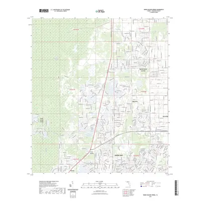
2023 Map of Weeki Wachee Spring
USGS Topo · Published 2023About this map
Weeki Wachee Spring serves as the focal point for this section of Florida’s Nature Coast, marking the headwaters where the Weeki Wachee River begins its flow toward the Gulf. The landscape is defined by the contrast between preserved wetlands and dense residential development. To the west, the Chassahowitzka Swamp and Weeki Wachee Swamp create a vast buffer of undeveloped terrain. Conversely, the eastern half of the map shows the extensive grid of Spring Hill and North Weeki Wachee, illustrating the rapid expansion of coastal communities. Transportation corridors like Commercial Way and Cortez Blvd anchor the local economy, connecting smaller settlements like High Point and Brookridge. Unique hydrology is visible at Great Hope Pond and Coon Wallow, while Weeki Wachee Gardens highlights the canal-based residential planning common to this part of Hernando County.
Find a feature on this map
90 named features on this map. Tap any name to fly to it.
Don’t see what you’re looking for? This feature index may not catch every label — zoom into the map to look around manually.
Map Details
Editions of this 2023 Weeki Wachee Spring Map
This is the sole edition of this map. No revisions or reprints were ever made.
Other maps of this area

1954 · Chassahowitzka Bay
USGS Topo · 1:24,000

1954 · Brooksville NW
USGS Topo · 1:24,000

1954 · Brooksville
USGS Topo · 1:24,000

1954 · Aripeka
USGS Topo · 1:24,000

1954 · Chassahowitzka
USGS Topo · 1:24,000

1954 · Bayport
USGS Topo · 1:24,000

1954 · Masaryktown
USGS Topo · 1:24,000

1954 · Weekiwachee Springs
USGS Topo · 1:24,000

1954 · Port Richey NE
USGS Topo · 1:24,000

1955 · Plant City
USGS Topo · 1:250,000