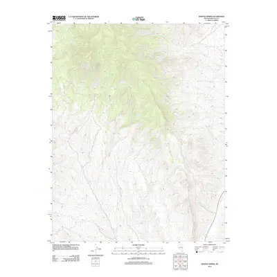
2012 Map of Weepah Spring
USGS Topo · Published 2012About this map
Weepah Spring sits at the heart of this high-desert basin in Lincoln County, where the landscape is defined by the ephemeral flow of the White River. This 2012 survey by the U. S. Geological Survey documents the subtle hydrography of the region, including the isolated water sources at White Rock Spring. The map captures a sparsely populated interior of Nevada where the orientation of drainage patterns and the presence of these permanent springs were historically vital for transit and livestock in an arid environment. The eastern edge of the quadrangle follows the course of the White River, illustrating the topographical low points that collect the runoff from the surrounding mountain ranges.
Find a feature on this map
3 named features on this map. Tap any name to fly to it.
Don’t see what you’re looking for? This feature index may not catch every label — zoom into the map to look around manually.
Map Details
Editions of this 2012 Weepah Spring Map
This is the sole edition of this map. No revisions or reprints were ever made.
Other maps of this area

1885 · Pioche
USGS Topo · 1:250,000

1886 · Pioche
USGS Topo · 1:250,000

1954 · Caliente
USGS Topo · 1:250,000

1956 · Lund
USGS Topo · 1:250,000

1959 · Caliente
USGS Topo · 1:250,000

1960 · Lund
USGS Topo · 1:250,000

1970 · Oreana Spring
USGS Topo · 1:24,000

1970 · Seaman Wash
USGS Topo · 1:24,000
1970 · Deadman Spring
USGS Topo · 1:24,000

1970 · Wheatgrass Spring
USGS Topo · 1:24,000