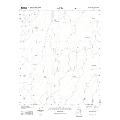
2011 Map of Weimer Point
USGS Topo · Published 2011About this map
The Mogollon Plateau landscape dominates this 2011 survey, defined by a complex network of canyons and high ridges. Significant water features such as Chevelon Canyon Lake and Chevelon Creek intersect the terrain, providing a vital resource for the livestock operations evident across the sheet. The prevalence of stock tanks, including Section Twenty Tank, Potato Patch Tank, and Houck Tank, indicates a landscape managed for ranching rather than dense settlement. Human habitation is sparse, centered on locations like Tillman Ranch and the interestingly named Potato Patch. Navigation through this backcountry relies on a system of forest service roads and established routes like Wildcat Rd and St Joe Rd. The map also captures several distinct family-named or descriptive landmarks, such as Weimer Point, Saint Joe Ridge, and Possum Point, which serve as primary orientation markers in this canyon-heavy environment.
Find a feature on this map
97 named features on this map. Tap any name to fly to it.
Don’t see what you’re looking for? This feature index may not catch every label — zoom into the map to look around manually.
Map Details
Editions of this 2011 Weimer Point Map
This is the sole edition of this map. No revisions or reprints were ever made.
Other maps of this area

1886 · Holbrook
USGS Topo · 1:250,000

1893 · Holbrook
USGS Topo · 1:250,000

1954 · Holbrook
USGS Topo · 1:250,000

1957 · Holbrook
USGS Topo · 1:250,000

1958 · Holbrook
USGS Topo · 1:250,000

1960 · Holbrook
USGS Topo · 1:250,000

1961 · Woods Canyon
USGS Topo · 1:62,500

1961 · Heber
USGS Topo · 1:62,500
1965 · Grama Draw
USGS Topo · 1:24,000

1965 · Chevelon Crossing
USGS Topo · 1:24,000