
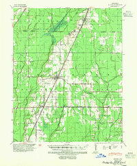
1939 Map of Weiner
USGS Topo · Published 1946About this map
The St Louis Southwestern RR dictates the development of the Arkansas Delta in this 1930s survey, connecting the primary hubs of Weiner and Waldenburg. The landscape is defined by an intricate network of drainage systems such as Lateral No 1 Ditch and Johnson Ditch, reflecting the era's massive efforts to reclaim agricultural land from the wetlands surrounding the L'Anguille River. This transition from swamp to farmland is punctuated by numerous rural educational centers, including Beautiful Home Sch, Cooper Haines Sch, and Ukana Sch, which served as the social anchors for scattered homesteads. Smaller rail-dependent points like O Bear Siding and Brainard reveal the shipping infrastructure required for the region's timber and agricultural output. Along the western edge, the complex hydrology of De View Bayou and Overcup Slough stands in contrast to the engineered precision of the newer ditches.
Find a feature on this map
40 named features on this map. Tap any name to fly to it.
Don’t see what you’re looking for? This feature index may not catch every label — zoom into the map to look around manually.
Map Details
Editions of this 1939 Weiner Map
3 editions found
Other maps of this area

1935 · Sedgwick
USGS Topo · 1:62,500

1935 · Alicia
USGS Topo · 1:62,500

1935 · Tuckerman
USGS Topo · 1:62,500

1939 · Vanndale
USGS Topo · 1:62,500

1939 · Weiner
USGS Topo · 1:62,500

1939 · Jonesboro
USGS Topo · 1:62,500

1940 · Princedale
USGS Topo · 1:62,500

1940 · Dee
USGS Topo · 1:62,500

1940 · Tilton
USGS Topo · 1:62,500

1953 · Memphis
USGS Topo · 1:250,000