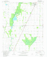
1980 Map of Weiner
USGS Topo · Published 1980About this map
The agricultural plains of Poinsett County are defined by a complex network of water management and conservation, anchored by the Bayou De View State Wildlife Management Area. This landscape is marked by the presence of Lake Hogue and numerous man-made features like the Sew Disp Pond and various Fish Hatchery sites, illustrating the intersection of natural wetlands and active land use. The St Louis Southwestern railroad cuts a straight diagonal across the terrain, passing through the primary settlements of Weiner and Waldenburg. Local landmarks such as Harmony Grove Ch and Zion Cem provide essential points for genealogical research. The map also captures specialized infrastructure like the Horst Landing Strip and several siphons and flumes, reflecting the intricate irrigation requirements of this delta region.
Find a feature on this map
28 named features on this map. Tap any name to fly to it.
Don’t see what you’re looking for? This feature index may not catch every label — zoom into the map to look around manually.
Map Details
Editions of this 1980 Weiner Map
This is the sole edition of this map. No revisions or reprints were ever made.
Other maps of this area

1935 · Tuckerman
USGS Topo · 1:62,500

1939 · Vanndale
USGS Topo · 1:62,500

1939 · Weiner
USGS Topo · 1:62,500

1940 · Tilton
USGS Topo · 1:62,500

1953 · Memphis
USGS Topo · 1:250,000

1956 · Memphis
USGS Topo · 1:250,000

1956 · Tilton
USGS Topo · 1:62,500

1958 · Vanndale
USGS Topo · 1:62,500

1959 · Weiner
USGS Topo · 1:62,500

1960 · Weiner
USGS Topo · 1:62,500