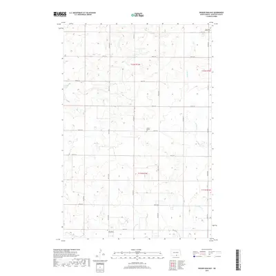
2018 Map of Weisser Dam East
USGS Topo · Published 2018About this map
Saint James Lutheran Cem and Friedens Lutheran Cem anchor the rolling agricultural terrain of this McIntosh County landscape. The map reveals a strictly organized grid of rural roads, including 30th Ave SE and 89th St SE, which facilitate movement between scattered homesteads and communal burial grounds. Small-scale water management and drainage are central to the area's geography, evidenced by the Weisser Dam and the meandering path of the S Br Beaver Cr. These features, along with the New Kassel E and R Cem, provide essential landmarks for genealogists tracing German-Russian settlement patterns in the Dakotas. The land remains largely divided by the Public Land Survey System, with township boundaries like t132n r73w and t131n r73w clearly defining the territory.
Find a feature on this map
23 named features on this map. Tap any name to fly to it.
Don’t see what you’re looking for? This feature index may not catch every label — zoom into the map to look around manually.
Map Details
Editions of this 2018 Weisser Dam East Map
This is the sole edition of this map. No revisions or reprints were ever made.
Other maps of this area

1953 · Jamestown
USGS Topo · 1:250,000

1956 · Jamestown
USGS Topo · 1:250,000

1979 · Schell Buttes
USGS Topo · 1:24,000

1979 · Schell Buttes SW
USGS Topo · 1:24,000
1980 · Hague
USGS Topo · 1:24,000
1980 · Weisser Dam West
USGS Topo · 1:24,000
1980 · Hague SE
USGS Topo · 1:24,000

1982 · Wishek SW
USGS Topo · 1:24,000

1982 · May Lake NW
USGS Topo · 1:24,000

1982 · May Lake SW
USGS Topo · 1:24,000