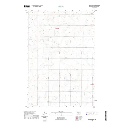
2020 Map of Weisser Dam East
USGS Topo · Published 2020About this map
New Kassel sits on the southern edge of this McIntosh County landscape, a region defined by its Lutheran heritage and agricultural grid. The terrain is marked by numerous small wetlands and drainage patterns that feed into the S Br Beaver Cr, while the namesake Weisser Dam anchors the western section. Genealogical interest is centered on three distinct burial grounds: Saint James Lutheran Cem in the northeast, Friedens Lutheran Cem near the center, and the New Kassel E and R Cem to the south. These sites reflect the settlement patterns of the German-Russian communities that established themselves in this part of North Dakota. A strictly organized network of section-line roads, including 85th St SE and 27th Ave SE, provides access to the isolated farmsteads and rolling prairie lands.
Find a feature on this map
24 named features on this map. Tap any name to fly to it.
Don’t see what you’re looking for? This feature index may not catch every label — zoom into the map to look around manually.
Map Details
Editions of this 2020 Weisser Dam East Map
This is the sole edition of this map. No revisions or reprints were ever made.
Other maps of this area

1953 · Jamestown
USGS Topo · 1:250,000

1956 · Jamestown
USGS Topo · 1:250,000

1979 · Schell Buttes
USGS Topo · 1:24,000

1979 · Schell Buttes SW
USGS Topo · 1:24,000
1980 · Hague
USGS Topo · 1:24,000
1980 · Weisser Dam West
USGS Topo · 1:24,000
1980 · Hague SE
USGS Topo · 1:24,000

1982 · Wishek SW
USGS Topo · 1:24,000

1982 · May Lake NW
USGS Topo · 1:24,000

1982 · May Lake SW
USGS Topo · 1:24,000