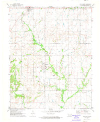
1971 Map of Welch South
USGS Topo · Published 1973About this map
Bluejacket and the southern edge of Welch anchor this northern Oklahoma landscape, defined by the prominent route of the Missouri - Kansas - Texas railroad. The line runs north-to-south through the center of the sheet, paralleling the winding course of Little Cabin Creek. This corridor served as a vital artery for the region's agricultural economy in the early 1970s, connecting small rail-side communities. To the west, Timber Hill provides a distinct topographic rise above the surrounding plains, while the local geography is further carved by numerous tributaries including Whisky Br, Crow Creek, and Wolf Creek. Genealogy and local history researchers will find the Bluejacket Cem south of its namesake town, alongside evidence of community infrastructure like the local Park and Sewage Disposal facility near Welch.
Find a feature on this map
16 named features on this map. Tap any name to fly to it.
Don’t see what you’re looking for? This feature index may not catch every label — zoom into the map to look around manually.
Map Details
Editions of this 1971 Welch South Map
This is the sole edition of this map. No revisions or reprints were ever made.
Other maps of this area

1901 · Vinita
USGS Topo · 1:125,000

1907 · Wyandotte
USGS Topo · 1:125,000

1909 · Wyandotte
USGS Topo · 1:125,000

1913 · Vinita
USGS Topo · 1:125,000

1954 · Tulsa
USGS Topo · 1:250,000

1958 · Tulsa
USGS Topo · 1:250,000
1961 · Miami NW
USGS Topo · 1:24,000

1961 · Miami SW
USGS Topo · 1:24,000

1963 · Tulsa
USGS Topo · 1:250,000
1971 · Pyramid Corners
USGS Topo · 1:24,000