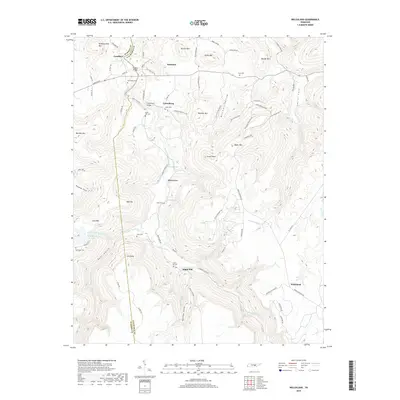
2019 Map of Welchland
USGS Topo · Published 2019About this map
Rocky River winds through the heart of this landscape, forming the natural boundary between Warren Co and Van Buren Co. The terrain is defined by high elevations and deep recesses, notably Dyer Gulch, Narrow Cove, and Douglas Cove, which constrain local travel to winding routes like Old State Hwy 30 and Baker Mountain Rd. Small settlements such as Goodbars, Harmony, and Riverview serve as local hubs, while the map reveals a high density of family and community burial sites. Genealogists will find a wealth of information in the placement of White Hill Cem, Crain Hill Cem, and New Rocky Cem. Infrastructure like the Goodbar Bridge and Laurelburg Bridge highlight the historical crossings required to navigate this deeply incised river valley.
Find a feature on this map
82 named features on this map. Tap any name to fly to it.
Don’t see what you’re looking for? This feature index may not catch every label — zoom into the map to look around manually.
Map Details
Editions of this 2019 Welchland Map
This is the sole edition of this map. No revisions or reprints were ever made.
Other maps of this area

1892 · Pikeville
USGS Topo · 1:125,000

1893 · Mc Minnville
USGS Topo · 1:125,000

1895 · Mc Minnville
USGS Topo · 1:125,000

1895 · Pikeville
USGS Topo · 1:125,000

1935 · Smart Mountain
USGS Topo · 1:24,000

1943 · Cookeville
USGS Topo · 1:100,000

1944 · Cookeville
USGS Topo · 1:100,000
1946 · Smartt Mountain
USGS Topo · 1:24,000
1947 · Smartt Mountain
USGS Topo · 1:24,000

1953 · Chattanooga
USGS Topo · 1:250,000