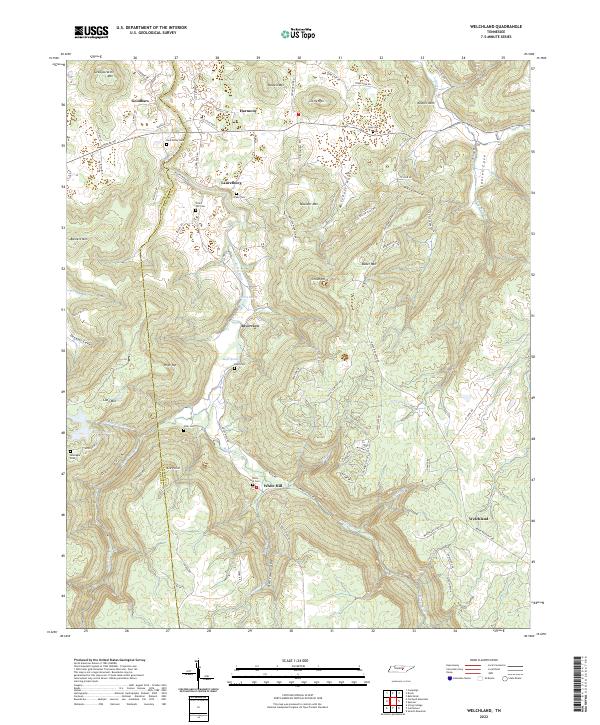
2022 Map of Welchland
USGS Topo · Published 2022About this map
The Rocky River carves a deep, winding path through this portion of the Cumberland Plateau, serving as a natural boundary between Warren and Van Buren counties. The landscape is defined by the transition from high summits like Russell Mtn and Turkeyscratch Mtn down into secluded valleys such as Laurel Cove and Narrow Cove. Small, dispersed settlements like Harmony, Laurelburg, and Welchland anchor the upland ridges, while the river's drainage system is fed by numerous named tributaries including Long Fork Cr and Sycamore Br.
Find a feature on this map
52 named features on this map. Tap any name to fly to it.
Don’t see what you’re looking for? This feature index may not catch every label — zoom into the map to look around manually.
Map Details
Editions of this 2022 Welchland Map
This is the sole edition of this map. No revisions or reprints were ever made.
Other maps of this area

1892 · Pikeville
USGS Topo · 1:125,000

1893 · Mc Minnville
USGS Topo · 1:125,000

1895 · Mc Minnville
USGS Topo · 1:125,000

1895 · Pikeville
USGS Topo · 1:125,000

1935 · Smart Mountain
USGS Topo · 1:24,000

1943 · Cookeville
USGS Topo · 1:100,000

1944 · Cookeville
USGS Topo · 1:100,000
1946 · Smartt Mountain
USGS Topo · 1:24,000
1947 · Smartt Mountain
USGS Topo · 1:24,000

1953 · Chattanooga
USGS Topo · 1:250,000