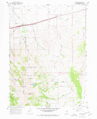
1967 Map of Welcome
USGS Topo · Published 1978About this map
The Southern Pacific and Western Pacific railroads parallel each other through the northern flats of this Elko County landscape, serving the small settlement of Welcome as they traverse the corridor between Starr Valley and Clover Valley. This 1960s survey documents a region defined by the stark transition from these transportation arteries to the high-elevation wilderness of the Humboldt National Forest. In the southern portion of the quadrangle, the terrain rises sharply into the East Humboldt Range, where Greys Peak towers over glacial features like Angel Lake, Smith Lake, and Greys Lake. The mapping of the Penstock Siphon Trail and the nearby Powerplant indicates the localized management of water and power, while an Open Pit Mine on the eastern slopes reflects the area's ongoing mineral interest. This era captures the early years of Interstate 80 as it supplanted U.S. 40 through the high desert.
Find a feature on this map
42 named features on this map. Tap any name to fly to it.
Don’t see what you’re looking for? This feature index may not catch every label — zoom into the map to look around manually.
Map Details
Editions of this 1967 Welcome Map
2 editions found
Other maps of this area

1935 · Halleck
USGS Topo · 1:125,000

1955 · Wells
USGS Topo · 1:250,000

1955 · Elko
USGS Topo · 1:250,000

1958 · Wells
USGS Topo · 1:250,000

1958 · Elko
USGS Topo · 1:250,000

1961 · Wells
USGS Topo · 1:250,000

1962 · Elko
USGS Topo · 1:250,000

1965 · Elko
USGS Topo · 1:250,000

1967 · Welcome
USGS Topo · 1:24,000

1967 · Herder Creek
USGS Topo · 1:24,000