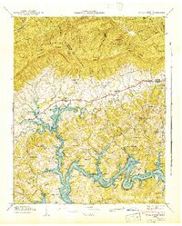
1942 Map of Well Spring
USGS Topo · Published 1942About this map
The Powell River and Norris Reservoir dominate the southern half of this Tennessee landscape, reflecting the massive hydrological changes of the early 1940s. While the rising waters of the reservoir reshaped the valley, the established settlements of Well Spring and Speedwell remain focused along the northern corridor near Cumberland Mountain. The map is particularly rich in genealogical data, preserving the locations of numerous family burial grounds such as Besler Cem, Childress Cem, and Jones Cem. Educational and social life is anchored by local institutions including the Speedwell Academy and various rural schools like Upper Flat Hollow Sch and Bethlehem Sch. Steep ridges like Chestnut Ridge and Whiteoak Ridge compartmentalize the terrain, forcing roads and settlements into the hollows and gaps that have historically defined movement through this part of Campbell, Claiborne, and Union Counties.
Find a feature on this map
65 named features on this map. Tap any name to fly to it.
Don’t see what you’re looking for? This feature index may not catch every label — zoom into the map to look around manually.
Map Details
Editions of this 1942 Well Spring Map
This is the sole edition of this map. No revisions or reprints were ever made.
Other maps of this area

1886 · Cumberland Gap
USGS Topo · 1:125,000

1888 · Cumberland Gap
USGS Topo · 1:125,000

1890 · Williamsburg
USGS Topo · 1:125,000

1891 · Cumberland Gap
USGS Topo · 1:125,000

1893 · Briceville
USGS Topo · 1:125,000

1894 · Williamsburg
USGS Topo · 1:125,000

1895 · Briceville
USGS Topo · 1:125,000

1896 · Briceville
USGS Topo · 1:125,000

1897 · Maynardville
USGS Topo · 1:125,000

1900 · Maynardville
USGS Topo · 1:125,000