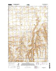
2017 Map of Well Spring
USGS Topo · Published 2017About this map
Well Spring and its surrounding canyon define this high-desert landscape in Morrow County, where water sources were once vital markers for travel through the region. This 2017 survey details the essential topography of the area, including Tub Springs and Strait Spring tucked into the draws. A significant point of interest for genealogists and local historians is the Wells Spring Cem, located near the intersection of Wells Springs Rd and Immigrant Ln. The road network, including the Ione-Boardman Rd and Grieb-Wood Rd, follows the long-established paths of early passage through these townships. The map clearly delineates the dry canyon systems of Well Spring Canyon and Juniper Canyon, providing a clear record of the area's natural drainage and historical land divisions.
Find a feature on this map
15 named features on this map. Tap any name to fly to it.
Don’t see what you’re looking for? This feature index may not catch every label — zoom into the map to look around manually.
Map Details
Editions of this 2017 Well Spring Map
This is the sole edition of this map. No revisions or reprints were ever made.
Other maps of this area

1906 · Blalock Island
USGS Topo · 1:125,000

1908 · Blalock Island
USGS Topo · 1:125,000

1953 · Pendleton
USGS Topo · 1:250,000

1956 · Pendleton
USGS Topo · 1:250,000

1962 · Boardman
USGS Topo · 1:24,000

1962 · Clarke
USGS Topo · 1:24,000

1962 · Crow Butte
USGS Topo · 1:24,000

1968 · Ione North
USGS Topo · 1:24,000
1968 · Strawberry Canyon NE
USGS Topo · 1:24,000
1968 · Strawberry Canyon SE
USGS Topo · 1:24,000