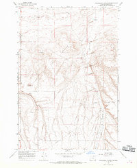
1968 Map of Strawberry Canyon NE
USGS Topo · Published 1970About this map
Boardman Bombing Range dominates the western edge of this Morrow County landscape, reflecting the military presence in the Oregon high desert during the late 1960s. The arid terrain is characterized by the prominent Finley Buttes and the expansive Sand Hollow, where numerous Sand Dunes are mapped in detail. Human activity is tied closely to water and transport, with isolated outposts like Sand Ranch and the Homestead settlement connected by a network of roads and trails. The necessity of groundwater in this environment is evident from the naming of specific sites such as Blacksmith Shop Well and West Well. A prominent pipeline cuts across the southeastern portion of the map, illustrating the infrastructure required to move resources through this sparse, sagebrush-dotted geography.
Find a feature on this map
16 named features on this map. Tap any name to fly to it.
Don’t see what you’re looking for? This feature index may not catch every label — zoom into the map to look around manually.
Map Details
Editions of this 1968 Strawberry Canyon NE Map
2 editions found
Other maps of this area

1906 · Blalock Island
USGS Topo · 1:125,000

1908 · Blalock Island
USGS Topo · 1:125,000

1908 · Umatilla
USGS Topo · 1:125,000

1953 · Pendleton
USGS Topo · 1:250,000

1956 · Pendleton
USGS Topo · 1:250,000

1962 · Ordnance
USGS Topo · 1:24,000

1962 · Boardman
USGS Topo · 1:24,000

1962 · Clarke
USGS Topo · 1:24,000

1968 · Service Buttes NW
USGS Topo · 1:24,000

1968 · Butter Creek Junction
USGS Topo · 1:24,000