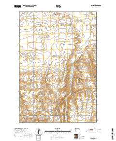
2020 Map of Well Spring
USGS Topo · Published 2020About this map
Well Spring and its surrounding canyonlands define this high-desert portion of Morrow County, where the topography is carved by a network of drainage systems. The presence of Wells Spring Cem and Immigrant Ln highlights the region's significance as a historic transit corridor, likely tracing portions of early pioneer routes. The landscape transitions from the higher elevations of Juniper Canyon to the more gradual slopes of Well Spring Canyon. Modern infrastructure is represented by a grid of rural connectors such as Wells Spring Rd and the Ione-Boardman Rd, which cross the surveyed townships of t3n r25e and t2n r25e. The map illustrates a contemporary rural environment where historical landmarks like the spring and cemetery remain preserved amidst the sprawling plateaus and deep canyons of eastern Oregon.
Find a feature on this map
11 named features on this map. Tap any name to fly to it.
Don’t see what you’re looking for? This feature index may not catch every label — zoom into the map to look around manually.
Map Details
Editions of this 2020 Well Spring Map
This is the sole edition of this map. No revisions or reprints were ever made.
Other maps of this area

1906 · Blalock Island
USGS Topo · 1:125,000

1908 · Blalock Island
USGS Topo · 1:125,000

1953 · Pendleton
USGS Topo · 1:250,000

1956 · Pendleton
USGS Topo · 1:250,000

1962 · Boardman
USGS Topo · 1:24,000

1962 · Clarke
USGS Topo · 1:24,000

1962 · Crow Butte
USGS Topo · 1:24,000

1968 · Ione North
USGS Topo · 1:24,000
1968 · Strawberry Canyon NE
USGS Topo · 1:24,000
1968 · Strawberry Canyon SE
USGS Topo · 1:24,000