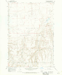
1968 Map of Well Spring
USGS Topo · Published 1970About this map
Oregon Trail and Immigrant Road markings highlight the enduring historical significance of this high desert terrain in Morrow County. As documented in the late 1960s, the landscape is defined by the Boardman Naval Bombing Range, which encompasses a large portion of the northern quadrangle. This military designation sits atop a geography of Sand Dunes and dramatic geological features like Juniper Canyon. Water sources were critical in this arid environment, evidenced by the clustered locations of Well Spring, Flowing Well, and Tub Spring. Near the primary spring, a small Cem (cemetery) serves as a poignant reminder of the early travelers and settlers who utilized these routes. The map illustrates a crossroads of transit history and modern defense, where mid-century military boundaries overlap with the tracks of 19th-century westward expansion.
Find a feature on this map
15 named features on this map. Tap any name to fly to it.
Don’t see what you’re looking for? This feature index may not catch every label — zoom into the map to look around manually.
Map Details
Editions of this 1968 Well Spring Map
This is the sole edition of this map. No revisions or reprints were ever made.
Other maps of this area

1906 · Blalock Island
USGS Topo · 1:125,000

1908 · Blalock Island
USGS Topo · 1:125,000

1953 · Pendleton
USGS Topo · 1:250,000

1956 · Pendleton
USGS Topo · 1:250,000

1962 · Boardman
USGS Topo · 1:24,000

1962 · Clarke
USGS Topo · 1:24,000

1962 · Crow Butte
USGS Topo · 1:24,000

1968 · Ione North
USGS Topo · 1:24,000
1968 · Strawberry Canyon NE
USGS Topo · 1:24,000
1968 · Strawberry Canyon SE
USGS Topo · 1:24,000