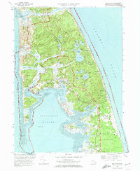
1972 Map of Wellfleet
USGS Topo · Published 1974About this map
Wellfleet and its surrounding coastal hamlets occupy this 1972 survey, revealing the intricate geography of the Outer Cape before modern development altered much of its rural character. The map details a landscape shaped by glacial kettle ponds like Gull Pond and Higgins Pond, alongside the winding saltwater estuaries of the Herring River and Blackfish Creek. Notable for historians is the inclusion of the Marconi Station Site and the National Seashore Headquarters, marking the region's transition into a protected federal landscape.
Find a feature on this map
98 named features on this map. Tap any name to fly to it.
Don’t see what you’re looking for? This feature index may not catch every label — zoom into the map to look around manually.
Map Details
Editions of this 1972 Wellfleet Map
3 editions found
Other maps of this area

1887 · Wellfleet
USGS Topo · 1:62,500

1887 · Provincetown
USGS Topo · 1:62,500

1889 · Provincetown
USGS Topo · 1:62,500

1889 · Wellfleet
USGS Topo · 1:62,500

1893 · Wellfleet
USGS Topo · 1:62,500

1898 · Provincetown
USGS Topo · 1:62,500

1942 · Cape Cod Bay
USGS Topo · 1:125,000

1942 · Nauset
USGS Topo · 1:125,000

1944 · Orleans
USGS Topo · 1:31,680

1944 · Wellfleet
USGS Topo · 1:31,680