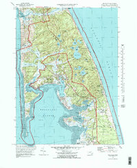
1972 Map of Wellfleet
USGS Topo · Published 1978About this map
Wellfleet and its surrounding coastal hamlets are detailed in this 1972 revision, showing the Outer Cape as it functioned before modern development patterns fully transformed the shoreline. The map documents the establishment of the Cape Cod National Seashore and includes the National Seashore Headquarters, marking a transition toward federal conservation. Significant local history is preserved in the placement of the Marconi Station Site and several small family burial grounds like Pine Grove Cem and Oakdale Cem. The landscape is defined by its complex hydrography, from the saltwater reaches of The Gut and Loagy Bay to numerous kettle ponds such as Gull Pond and Horseleech Pond. Narrow roads like Kings Highway and Old County Road trace the interior, connecting South Wellfleet to the landing at Pamet Harbor to the north.
Find a feature on this map
89 named features on this map. Tap any name to fly to it.
Don’t see what you’re looking for? This feature index may not catch every label — zoom into the map to look around manually.
Map Details
Editions of this 1972 Wellfleet Map
3 editions found
Other maps of this area

1887 · Wellfleet
USGS Topo · 1:62,500

1887 · Provincetown
USGS Topo · 1:62,500

1889 · Provincetown
USGS Topo · 1:62,500

1889 · Wellfleet
USGS Topo · 1:62,500

1893 · Wellfleet
USGS Topo · 1:62,500

1898 · Provincetown
USGS Topo · 1:62,500

1942 · Cape Cod Bay
USGS Topo · 1:125,000

1942 · Nauset
USGS Topo · 1:125,000

1944 · Orleans
USGS Topo · 1:31,680

1944 · Wellfleet
USGS Topo · 1:31,680