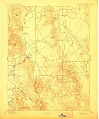
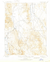
1893 Map of Wellington
USGS Topo · Published 1911About this map
Wellington serves as a central hub in this high-desert landscape, situated where the West Walker River transitions from its canyon descent into the broader expanse of Smith Valley. Surveyed in 1890, the map records the early industrial and agricultural footprint along the borderlands of California and Nevada, featuring the Ludwig Mine in the north and the concentrated mining area around Pine Grove and Rockland to the southeast. The geography is defined by significant elevation changes, from the Sweetwater Mts to the seasonal hydrology of Alkali Flat and Little Alkali Lake. Settled outposts like The Colony and Hinds Hot Springs suggest a period when irrigation and mineral wealth were drawing new residents to these arid valleys. The California Nevada Boundary Line cuts diagonally across the southern portion of the sheet, separating the mountain terrain of Mono County from the basin lands of Esmeralda.
Find a feature on this map
38 named features on this map. Tap any name to fly to it.
Don’t see what you’re looking for? This feature index may not catch every label — zoom into the map to look around manually.
Map Details
Editions of this 1893 Wellington Map
6 editions found
Other maps of this area

1889 · Markleeville
USGS Topo · 1:125,000

1891 · Carson
USGS Topo · 1:125,000

1891 · Markleeville
USGS Topo · 1:125,000

1891 · Wabuska
USGS Topo · 1:125,000

1891 · Wellington
USGS Topo · 1:125,000

1893 · Carson
USGS Topo · 1:125,000

1893 · Markleeville
USGS Topo · 1:125,000

1893 · Wellington
USGS Topo · 1:125,000

1894 · Wabuska
USGS Topo · 1:125,000

1896 · Dardanelles
USGS Topo · 1:125,000