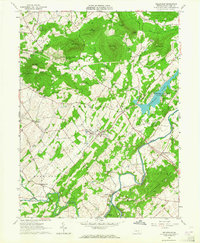
1963 Map of Wellsville
USGS Topo · Published 1964About this map
Wellsville and the surrounding York County countryside are documented here in the early 1960s, a period marked by the creation of Gifford Pinchot State Park. This recreation area dominates the eastern landscape, centered on Conewago Lake and the winding course of Conewago Creek. To the west, the terrain rises toward the forested ridges of State Game Lands No 242 and peaks like Round Top.
Find a feature on this map
59 named features on this map. Tap any name to fly to it.
Don’t see what you’re looking for? This feature index may not catch every label — zoom into the map to look around manually.
Map Details
Editions of this 1963 Wellsville Map
3 editions found
Other maps of this area

1904 · Carlisle
USGS Topo · 1:62,500

1906 · New Cumberland
USGS Topo · 1:62,500

1908 · Gettysburg
USGS Topo · 1:62,500

1920 · Hanover
USGS Topo · 1:62,500

1922 · Hanover
USGS Topo · 1:62,500

1942 · Gettysburg
USGS Topo · 1:125,000

1943 · New Cumberland
USGS Topo · 1:62,500

1943 · Carlisle
USGS Topo · 1:62,500

1944 · Hampton
USGS Topo · 1:31,680

1948 · Baltimore
USGS Topo · 1:250,000