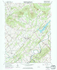
1963 Map of Wellsville
USGS Topo · Published 1977About this map
Wellsville and its surrounding townships in York County are defined by a mix of agricultural valley lands and prominent wooded summits like Nells Hill and Pinetown Hill. This mid-century landscape shows a transition toward recreation with the development of Gifford Pinchot State Park and Conewago Lake in the east, while the western portion remains dominated by traditional settlements and farming tracts. The map records numerous family and community landmarks, including Detters Mill, Mt Zion Ch, and Chestnut Grove Cem, reflecting a long-established rural social fabric. The drainage patterns of Bermudian Cr and Beaver Creek dictate the local topography, carving through the Dover Mountains in the southeast. These physical features, alongside extensive State Game Lands No 242, illustrate the persistence of public and natural spaces amidst the growing communities of Rossville and Kralltown.
Find a feature on this map
58 named features on this map. Tap any name to fly to it.
Don’t see what you’re looking for? This feature index may not catch every label — zoom into the map to look around manually.
Map Details
Editions of this 1963 Wellsville Map
3 editions found
Other maps of this area

1904 · Carlisle
USGS Topo · 1:62,500

1906 · New Cumberland
USGS Topo · 1:62,500

1908 · Gettysburg
USGS Topo · 1:62,500

1920 · Hanover
USGS Topo · 1:62,500

1922 · Hanover
USGS Topo · 1:62,500

1942 · Gettysburg
USGS Topo · 1:125,000

1943 · New Cumberland
USGS Topo · 1:62,500

1943 · Carlisle
USGS Topo · 1:62,500

1944 · Hampton
USGS Topo · 1:31,680

1948 · Baltimore
USGS Topo · 1:250,000