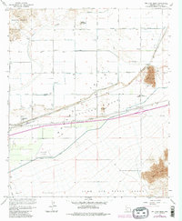
1965 Map of Wellton Mesa
USGS Topo · Published 1982About this map
Gila River waters define the northern reaches of this Arizona landscape, where the Mohawk Canal and Wellton Mohawk Main Channel drive a highly organized grid of desert agriculture. Small settlements like Asher and Noah punctuate the map along the Southern Pacific railroad line, serving as local hubs in the Mohawk Valley. The transition from the irrigated valley floor to the arid Wellton Mesa is marked by distinctive geological features like Antelope Hill and Radar Hill.
Find a feature on this map
39 named features on this map. Tap any name to fly to it.
Don’t see what you’re looking for? This feature index may not catch every label — zoom into the map to look around manually.
Map Details
Editions of this 1965 Wellton Mesa Map
4 editions found
Other maps of this area

1926 · Wellton
USGS Topo · 1:62,500

1926 · Mohawk
USGS Topo · 1:62,500

1928 · Mohawk
USGS Topo · 1:62,500

1928 · Norton
USGS Topo · 1:62,500

1929 · Wellton
USGS Topo · 1:62,500

1929 · Norton
USGS Topo · 1:62,500

1942 · Yuma
USGS Topo · 1:250,000

1953 · Ajo
USGS Topo · 1:250,000

1954 · El Centro
USGS Topo · 1:250,000

1955 · El Centro
USGS Topo · 1:250,000