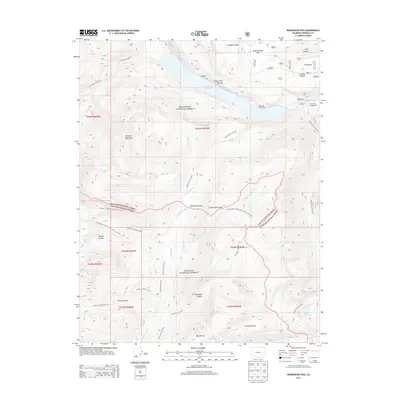
2013 Map of Weminuche Pass
USGS Topo · Published 2013About this map
The Continental Divide bisects this high-elevation landscape, where the headwaters of the Rio Grande Reservoir meet the rugged boundaries of the Rio Grande National Forest and San Juan National Forest. This 2013 survey highlights a complex network of wilderness transit, notably the Continental Divide National Scenic Trail and the Weminuche Pass, a critical geographic gate between the Atlantic and Pacific watersheds. Historically significant infrastructure for water management is evident through the Raber-Lohr Ditch and Fuchs Ditch, diverting flows across this difficult terrain. The map records several named rincons, such as Rincon La Vaca and Rincon La Osa, alongside early logistical points like Stage Station Flat. Recreational and forestry sites like the Thirtymile Campground and Reservoir Picnic Area emphasize the area's dual role as a managed resource and a destination for back-country exploration.
Find a feature on this map
45 named features on this map. Tap any name to fly to it.
Don’t see what you’re looking for? This feature index may not catch every label — zoom into the map to look around manually.
Map Details
Editions of this 2013 Weminuche Pass Map
This is the sole edition of this map. No revisions or reprints were ever made.
Other maps of this area

1905 · San Cristobal
USGS Topo · 1:125,000

1907 · San Cristobal
USGS Topo · 1:125,000

1945 · Durango
USGS Topo · 1:250,000

1953 · Durango
USGS Topo · 1:250,000

1954 · Durango
USGS Topo · 1:250,000

1959 · Bristol Head
USGS Topo · 1:62,500

1961 · Durango
USGS Topo · 1:250,000

1963 · Durango
USGS Topo · 1:250,000
1964 · Rio Grande Pyramid
USGS Topo · 1:24,000
1964 · Finger Mesa
USGS Topo · 1:24,000