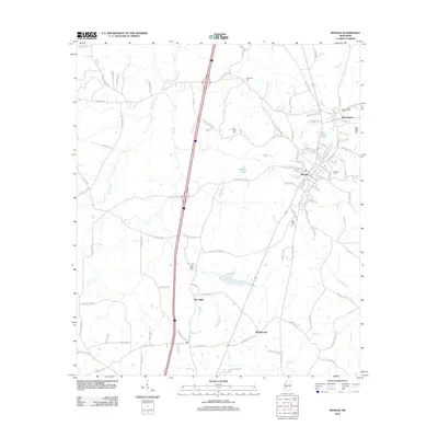
2012 Map of Wesson
USGS Topo · Published 2012About this map
Wesson and the neighboring settlement of Beauregard anchor the northeastern landscape of this Copiah and Lincoln County survey. The Illinois Central railroad corridor serves as a primary north-south axis, historically vital for the transit of goods and people through this timber-rich region. The map reveals a high concentration of community landmarks, particularly a network of local burial grounds such as Sylvarena Cem, Rocky Hill Cem, and Wesson Cem, which offer significant value for genealogical research. To the west and south, the terrain is defined by the winding waters of Bayou Pierre and Clear Cr, alongside smaller communities like New Sight and Montgomery. This detailed view from the early 2010s documents a landscape of mixed rural agriculture and established rail-town commerce, reflecting the enduring patterns of Mississippi's hill country settlement.
Find a feature on this map
122 named features on this map. Tap any name to fly to it.
Don’t see what you’re looking for? This feature index may not catch every label — zoom into the map to look around manually.
Map Details
Editions of this 2012 Wesson Map
This is the sole edition of this map. No revisions or reprints were ever made.
Other maps of this area

1953 · Natchez
USGS Topo · 1:250,000

1956 · Natchez
USGS Topo · 1:250,000

1959 · Natchez
USGS Topo · 1:250,000

1963 · Smyrna
USGS Topo · 1:24,000

1963 · Hazlehurst
USGS Topo · 1:24,000

1963 · Shady Grove
USGS Topo · 1:24,000

1972 · Fair Oak Springs
USGS Topo · 1:24,000

1972 · Midway
USGS Topo · 1:24,000
1972 · Stronghope
USGS Topo · 1:24,000

1972 · Brookhaven
USGS Topo · 1:24,000