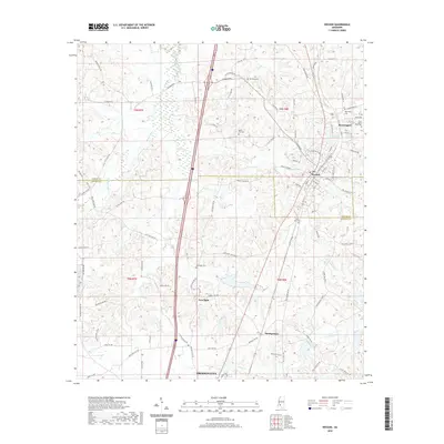
2020 Map of Wesson
USGS Topo · Published 2020About this map
Wesson and Beauregard anchor the northern reaches of this Mississippi survey, where the rail corridor of E Railroad Ave and W Railroad Ave remains a central feature of the landscape. The terrain is defined by the headwaters of several drainages, including Bayou Pierre and Little Bahala Cr, which create a network of ridges and hollows that historically dictated settlement patterns. This modern topographic record is particularly valuable for genealogists, as it meticulously identifies numerous local burial sites such as Sylvarena Cem, Rocky Hill Cem, and Saint Peter Rock Cem.
Find a feature on this map
102 named features on this map. Tap any name to fly to it.
Don’t see what you’re looking for? This feature index may not catch every label — zoom into the map to look around manually.
Map Details
Editions of this 2020 Wesson Map
This is the sole edition of this map. No revisions or reprints were ever made.
Other maps of this area

1953 · Natchez
USGS Topo · 1:250,000

1956 · Natchez
USGS Topo · 1:250,000

1959 · Natchez
USGS Topo · 1:250,000

1963 · Smyrna
USGS Topo · 1:24,000

1963 · Hazlehurst
USGS Topo · 1:24,000

1963 · Shady Grove
USGS Topo · 1:24,000

1972 · Fair Oak Springs
USGS Topo · 1:24,000

1972 · Midway
USGS Topo · 1:24,000
1972 · Stronghope
USGS Topo · 1:24,000

1972 · Brookhaven
USGS Topo · 1:24,000