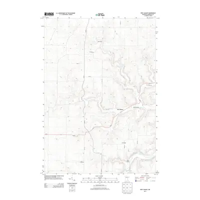
2013 Map of West Albany
USGS Topo · Published 2013About this map
West Albany sits at the junction of Spring Cr and MN-60, serving as the primary hub in this deeply dissected corner of Wabasha County. The landscape is defined by the winding Zumbro River to the south and a series of dramatic geographic depressions and elevations, from the steep-walled Hell Coulee and Hungry Hollow to the high ground of Irish Ridge. This topography has historically dictated the settlement patterns and road networks that follow the valley floors and ridgelines.
Find a feature on this map
31 named features on this map. Tap any name to fly to it.
Don’t see what you’re looking for? This feature index may not catch every label — zoom into the map to look around manually.
Map Details
Editions of this 2013 West Albany Map
This is the sole edition of this map. No revisions or reprints were ever made.
Other maps of this area

1932 · Wabasha
USGS Topo · 1:62,500

1934 · Plainview
USGS Topo · 1:62,500

1935 · Rochester
USGS Topo · 1:48,000

1938 · Plainview
USGS Topo · 1:62,500

1939 · Rochester
USGS Topo · 1:62,500

1951 · Wabasha
USGS Topo · 1:62,500

1951 · Lake City
USGS Topo · 1:62,500

1953 · Saint Paul
USGS Topo · 1:250,000

1959 · Saint Paul
USGS Topo · 1:250,000
1972 · Plainview
USGS Topo · 1:24,000