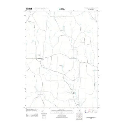
2013 Map of West Bainbridge
USGS Topo · Published 2013About this map
Coventryville and West Bainbridge serve as the primary nodes of settlement in this Chenango County landscape, where small hamlets are connected by a network of rural routes like Co RD-27 and Co RD-17. The terrain is defined by the drainage patterns of Wilkins Brook and Kelsey Cr, which carve through the valley between local heights such as Gibson Pinnacle and Roberts Hill. This 2013 survey illustrates a modern rural economy that maintains its recreational and transport roots, as seen in the presence of The New Echo Lake Resort and aviation facilities like Miller Field Airport and North Fork Airport. Genealogists will find significant local history preserved in the several burial grounds dotting the hillsides, including Coventryville Cem, W Bainbridge Cem, and Yaleville Cem. The map provides a detailed view of the transition between agrarian tracts and the wooded uplands surrounding Brackett Lake and Mud Pond.
Find a feature on this map
78 named features on this map. Tap any name to fly to it.
Don’t see what you’re looking for? This feature index may not catch every label — zoom into the map to look around manually.
Map Details
Editions of this 2013 West Bainbridge Map
This is the sole edition of this map. No revisions or reprints were ever made.
Other maps of this area

1902 · Coventry
USGS Topo · 1:62,500

1904 · Oxford
USGS Topo · 1:62,500

1905 · Nineveh
USGS Topo · 1:62,500

1915 · Unadilla
USGS Topo · 1:62,500

1918 · Unadilla
USGS Topo · 1:62,500

1924 · Deposit
USGS Topo · 1:62,500

1926 · Deposit
USGS Topo · 1:62,500

1943 · Sidney
USGS Topo · 1:24,000
1943 · Guilford
USGS Topo · 1:24,000

1944 · Deposit
USGS Topo · 1:62,500