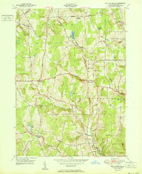
1951 Map of West Bainbridge
USGS Topo · Published 1951About this map
West Bainbridge and its surrounding hamlets are defined by a network of creeks and ridges in Chenango County as they appeared in the early 1950s. The landscape is marked by prominent elevations such as Gibson Pinnacle and the area known as Bumps, while the valleys carry Kelsey Creek and Wilkins Brook. This era shows a settled rural economy, with small clusters of homes and family-named locations like Blakesley Corner, Puckerville Corners, and Yaleville still distinctly labeled. For those tracing local heritage, the map identifies landmarks such as the West Bainbridge Cem and several other cemeteries, alongside smaller water bodies like Echo Lake, Brackett Lake, and Smith Pond. The road network consists largely of named routes like Scouten Hill Road and Kilroy Road, providing a detailed look at the connectivity between the townships of Coventry, Bainbridge, and Afton before the significant modern expansion.
Find a feature on this map
43 named features on this map. Tap any name to fly to it.
Don’t see what you’re looking for? This feature index may not catch every label — zoom into the map to look around manually.
Map Details
Editions of this 1951 West Bainbridge Map
This is the sole edition of this map. No revisions or reprints were ever made.
Other maps of this area

1902 · Coventry
USGS Topo · 1:62,500

1904 · Oxford
USGS Topo · 1:62,500

1905 · Nineveh
USGS Topo · 1:62,500

1915 · Unadilla
USGS Topo · 1:62,500

1918 · Unadilla
USGS Topo · 1:62,500

1924 · Deposit
USGS Topo · 1:62,500

1926 · Deposit
USGS Topo · 1:62,500

1943 · Sidney
USGS Topo · 1:24,000
1943 · Guilford
USGS Topo · 1:24,000

1944 · Deposit
USGS Topo · 1:62,500