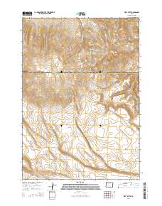
2014 Map of West Butte
USGS Topo · Published 2014About this map
The high desert landscape of central Oregon is defined by the sharp elevations of West Butte and the Bear Creek Buttes as they stood in 2014. Spanning the boundary between Crook County and Deschutes County, this terrain is marked by essential water sources in an otherwise arid region. Named features such as Daly Spring, Odell Spring, and Tub Spring dot the landscape, feeding into a drainage system that includes Williamson Cr and the ephemeral Dry River. Human intervention in this environment is visible through the Daly Reservoir and Hirsch Reservoir, which capture runoff for ranching or land management. Transportation is limited to a few arterial routes, most notably the S Crooked River Hwy cutting through the eastern corner and the George Millican Rd navigating the southwest, illustrating the sparse settlement and reliance on established water points for survival in the High Lava Plains.
Find a feature on this map
18 named features on this map. Tap any name to fly to it.
Don’t see what you’re looking for? This feature index may not catch every label — zoom into the map to look around manually.
Map Details
Editions of this 2014 West Butte Map
This is the sole edition of this map. No revisions or reprints were ever made.
Other maps of this area

1946 · Eagle Rock
USGS Topo · 1:62,500

1948 · Eagle Rock
USGS Topo · 1:62,500

1955 · Crescent
USGS Topo · 1:250,000

1955 · Bend
USGS Topo · 1:250,000

1957 · Crescent
USGS Topo · 1:250,000

1957 · Bend
USGS Topo · 1:250,000

1958 · Crescent
USGS Topo · 1:250,000

1958 · Bend
USGS Topo · 1:250,000

1962 · Powell Buttes
USGS Topo · 1:62,500

1966 · Millican SE
USGS Topo · 1:24,000